TOPOGRAPHIC MAPS OF EASTERN EUROPE
An Atlas of the Shtetl
A Startling Discovery
Th Atlas of the Shtetl emerged as a project in 2010 from the desire to know more about ancestral Jewish communities in Eastern Europe. While searching for the locality from which a close ancestor emigrated to the United States I became aware that bound atlases would not hold a useful map. Better maps that would show the smallest towns and villages in nineteenth century Eastern Europe would be required. Though persistence I found The Third Military Mapping Survey of the Austro-Hungarian Army linked at the JRI-Poland website. This resource contains 267 topographic maps (scale 1:200,000) of Central and Eastern Europe. Within a short time I had located the small village I was looking for.

The size of this resource was truly astounding at the time, but the limits of its coverage were immediately apparent. The northern and eastern boundaries of this map system needed to be extended in order to find the communities of my other ancestors from Eastern Europe, expressly those from the Pale of Settlement. I was struck by the detail of these maps and the ease with which I was able to download the images, but finding more resources like this was an obvious project. With this in mind a search for more maps began.
Soon I found that libraries at major Universities across the United States as well as the Library of Congress contained thousands of historical maps of these regions. Ten years on, we see many websites with large volumes of historical map images offered for download. Wading through the resources to find the most useful images for location study is a lengthy process, but the results can be quite useful. Historical maps give us a look at the land in the time-frame of our ancestors, ancestors whose traces exist in other sources of information but whose origin and home may remain visually obscure.
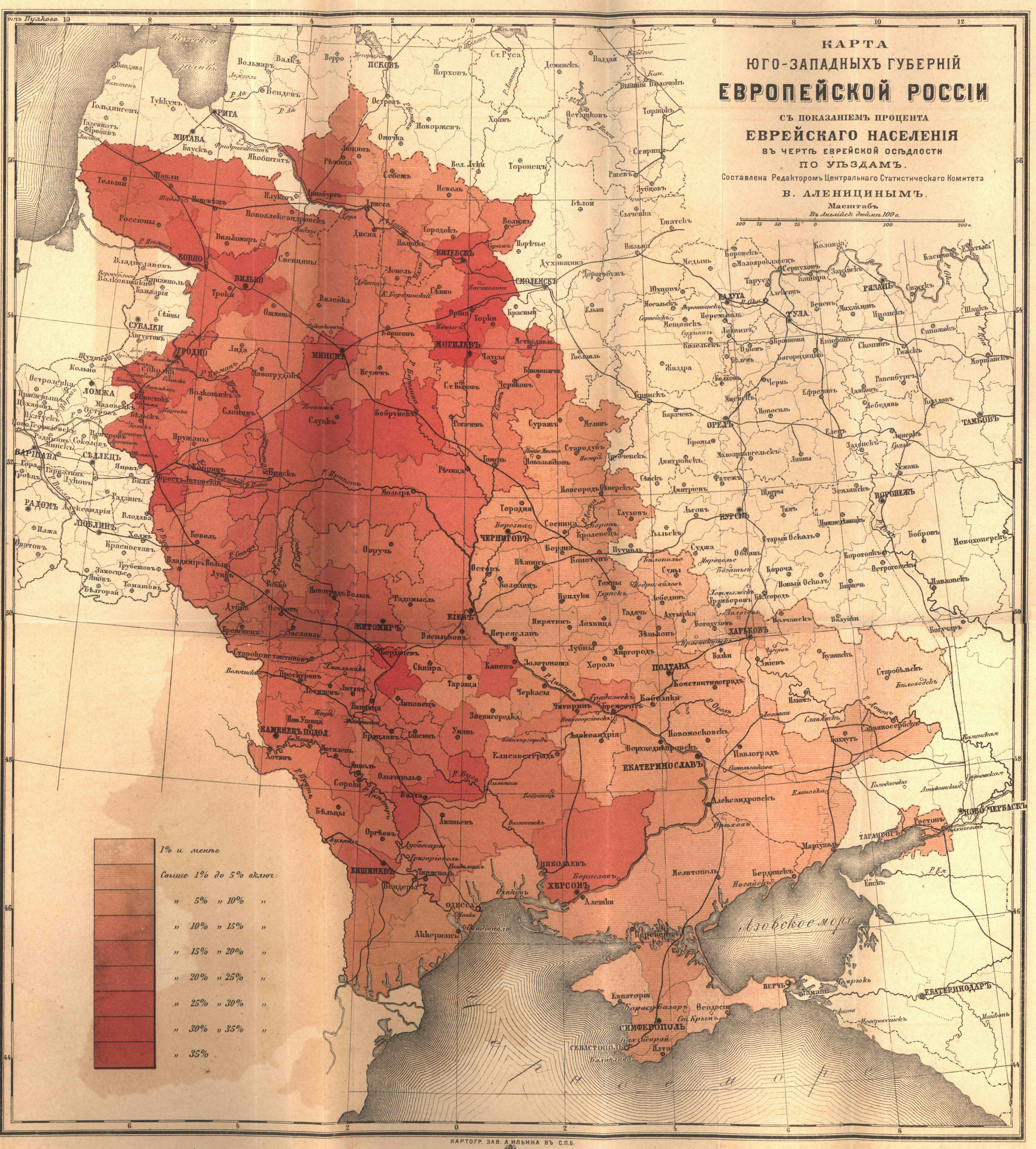
We know that the history of Europe is marked very much by changing boundaries and many of these shifts can be charted using historical maps. Additionally, historical maps can give us the country, province, administrative district and in some cases even the farm or estate that our ancestors lived on. We can see modes of transport, other forms of infrastructure and in some cases the presence of individual synagogues and cemeteries, distilleries, taverns, mills, tanneries and factories.
History Through Maps: Changing Boundaries
At the time of the first Partition of Poland (1772) mapping and cartographic science were entering a new era and leaders, especially Catherine II, would value maps both as military tools and as projections of power in the quest for Imperial expansion. In fact, her army raided Polish map collections in Warsaw during the final partition of Poland in 1795 (1). The interest and the need for maps spawned a lot of activity by military mappers across Europe as well as theft of map archives. During the 19th century large scale topographic map systems were created by the Partitioning powers for large portions of the continent. Later, many maps were stolen by Prussia and the Third Reich and altered for military use in the two world wars.
Historical atlases reveal that the partitioning of the Polish-Lithuanian Commonwealth was by far the most significant event affecting the lives of Jews in Eastern Europe heading into the nineteenth century. The Partitioning of Poland meant that the majority of the Jews of former Poland-Lithuania now resided in the Russian empire, where they had been most recently expelled in 1742 by Empress Elizabeth Petrovna. Territory won in the Russo-Turkish wars (1768-74) included regions inhabited by much smaller numbers of Jews and their settlement in newly established colonies along the Black Sea would soon be encouraged. In order to effectively administer and promote the economy the territory was re-apportioned into a system of guberniias and uezdy (counties). Little of the former Polish system remained. New laws and decrees changed patterns of Jewish residence, commercial activity and later demanded military conscription of the Jews across the newly delineated regions. Some laws were enacted to limit Jewish residence, others contained incentives for Jews to migrate southward to the province of New Russia (Novorossia) in order to develop agriculture. Official languages changed with the shifting borders, affecting documentation and in some cases the education of our ancestors. Jews were not permitted to conduct official business in Yiddish and were required to learn German, Polish or Russian if attending public school.
By knowing the proximity of the changing borders to the communities of our ancestors we can generally know more about their lives. Did an ancestor live in the Pale, or in Congress Poland? The latter (formerly part of the Duchy of Warsaw) became part of Russia after 1815. However, laws affecting Jews differed across these regions. In 1791 Catherine II issued an ukaze (a decree) to limit the residence and commercial activity of the Jews largely based on political pressures from the dominant merchants of Moscow. Later, the new governors of the western guberniia would bring similar complaints to Tsar Alexander I. In 1804 legislation on restrictions for residence and occupations resulted in the comprehensive law referred to as the Statute on the Organization of the Jews. This law specified the largest area the Pale would extend, including Astrakhan and Caucasia. In 1835 the Pale would reduce in size and assume its final delineation and official naming under Nicholas I. Movement and commercial activity across the western Russian boundary had been a concern for Catherine who banned many western goods and feared revolutionary literature from France (2). Under Nicholas the border came under greater control. The government reacted to widespread smuggling by placing a restriction to new Jewish residence along the western boundary within a 50 verst limit, or about 33 kilometers. Later during the reign of Alexander II laws would be passed (1859-1862) permitting some privileged Jews, military veterans and members of certain guilds to live outside the Pale's limits ie. to the north or eastward into the Russian interior. By 1868 Jews were permitted to pass freely from Congress Poland into the Russian Pale, but after the assination of Alexander II, laws would be enacted severly restricting residence and occupations in 1882, also chronicled here.
But for roughly two million people, the only solution to the increasing poverty and anti-semitism was departure. Certainly migration through or out of the Pale can be traced using historical maps containing rail lines. Towns like Brody in Galicia were major conduits for Jews heading away from the Pale and a lot of Jewish migration took place across the border of the northern Pale and East Prussia. In some cases we can pinpoint crossing points on these maps. Interestingly, we find taverns dotting the borders on many of the maps. Some regions were struck by famines, others by pogroms. Did one's ancestors face these realities, and if so, how did their position within the landscape impact their survival?
Historical maps can provide useful information supporting answers to many questions for the family historian. It has been my experience that many of my Jewish friends are still not sure of where the Pale exactly was or if an ancestor lived within its limits. Among the goals of this site is an extensive collection of large scale topographic maps for the entire area within the Pale of Settlement and regions to the west. Jewish communities are identified on these large scale editions and links are provided giving historical and geographic information for each Jewish community. Small scale maps of these regions are also offered giving many different views of the changing boundaries. Links to other on-line map archives are included as well. Both a small, and large scale view offers the researcher the best set of tools to understand regional as well as local histories. This collection is a being continually expanded and updated. The intention is to help viewers attain a better understanding of the historical geography of the Eastern European countries, regions and communities where their ancestors lived to better know their Place in Time.
Hap Ponedel
Eugene, OR
1. Steven Seegal, Mapping Europe's Borderlands
Russian Cartography in the Age of Empire, University of Chicago
Press, 2012, p.23.
2. Yohanan Petrovsky-Stern, The Golden Age Shtetl
A New History of Jewish Life in East Europe,
Princeton University Press, 2014, p.58.
