Rail Maps of Europe and Russia
|
Transportation Map of the Russian Empire (1854) J.A. Jungmeister
|
 |
|
Carte Generale des Routes des Chemins de Fer de L'Europe (1866) J.Andriveau-Goujon
|
 |
|
Special-Karte der Eisenbahn-Post-und Dampschiff-Verbindungen Mittel-Europas (1874) C.J.C. Raab
Source: Bibliotheque national de France |
 |
|
Eisenbahn und Schiffahrts-Karte der Kaiserreiche von Russland und der Turkei (1892) E.G. Ravenstein
Source: Bibliotheque national de France |
 |
|
Eisenbahnkarte des oestlichen Europa mit besonderer Berucksichtigung des russischen Reichesücksichtigung des russischen Reiches (1891) E. Gourdoux
Source: Bibliotheque national de France |
 |
|
Carte Kilometrique Chemins de fer de l'Europe (1899) E. Gourdoux
Source: Bibliotheque national de France |
 |
|
Eisenbahn und verkehrsatlas von Europa: Russland (1905) W. Koch
Full listing by this author at David Rumsey.
Source: The David Rumsey Collection |
 |
|
Eisenbahn und verkehrsatlas von Europa: Osterreich-Ungarn (1905) W. Koch
Source: The David Rumsey Collection |
 |
|
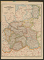
Eisenbahn und verkehrsatlas von Europa: Deutsches Reich (1905) W. Koch
Source: The David Rumsey Collection |
 |
|
Карта пароходныхъ сообщений, желъзныхъ и почтовыхъ дорогъ Российской Империи (1911) A. Il'ina
Karta porohodnyh" soobŝenìj zelĕznyh" i počtovyh" dorog" Rossìjskoj Imperìi
Map of shipping communications, railway and postal roads of the Russian Empire |
 |
|
Mapa Krolestwa Polskiego (1907) P.A. Baracza
A version from 1912 with county divisions, additional rail lines and a new border in Lublin province.
Further changes and additions in this 1915 version.
Source: The National Library of Poland |
 |
|
Artaria's Eisenbahnkarte von Osterreich-Ungarn und den Balkanlandern (1907) P.A. Baracza
A version from 1901 from hungaricana.hu
Source: Wikipedia |
 |
