Galicia, Bukovina
Galicia
Region in southeastern Poland and northwestern Ukraine. Galicia existed as a crown land of the Habsburg Empire from the time of the first partition of Poland in 1772 until the end of World War I in 1918. (The name Galicia, or Galizien, was derived from Halicz, a city with nearby salt mines.) It included the districts of Zamość, Sandomierz, and Chełm until these were annexed to the Grand Duchy of Warsaw in 1809. During the Congress of Vienna (1814–1815), Austria gained back the regions of Tarnopol (Ukr., Ternopil’) to the east, which it had ceded to the Russian Empire in 1809, and Kraków to the west. Kraków itself gained the status of a free city and remained so until after the Polish uprising of 1846, when it became an Austrian territory.
Full article at the YIVO Encyclopedia
After the 1772 Annexation to Austria
At the time of the region's annexation to Austria in 1772, its Jewish population numbered 224,980 (9.6% of the total). Jews were to be found in 187 cities, 93 small towns, and 5,467 villages and homesteads. By 1773 the number of Jews had declined to 171,851 (6.5%), and by 1776 to 144,200. In 1780 the Jewish population stood at 151,302; in 1782 at 172,424, and in 1785 at 212,002. In 1776 the area in the region of Cracow was extracted from Austria, but it was returned in 1795 and structured administratively as "western Galicia" (including the *Lublin district). Until 1809 the Zamosc district was also in Galicia, under Austria, and between 1786 and 1818 *Bukovina was included administratively in Galicia. In 1815–46 Cracow and its environs constituted an autonomous republic, while the Ternopol district came under Russian rule, during 1809–15.
Full article at the Jewish Virtual Library
Bukovina
The region between the E. Carpathians and the upper Dniester, part of Ottoman Moldavia until 1775, when it passed to the Austrian Empire as a result of theKutsug-Kainargi peace treaty (the entire region named Bukovina from 1774); after World War I incorporated into Romania. The main town of Bukovina is *Chernovtsy , formerly Czernowitz (see entry for some major aspects of Jewish life in the region. Czernowitz is the German form of the city's name; in Romanian it is called Cernauti, in Ukrainian Tsernivcy). Jewish merchants passing through Bukovina are mentioned from the 13th century, and Jews settled there from the 14th century. In 1408 they were granted the right of freedom of movement and commerce along the Moldavian trade routes. The Jewish population increased steadily, and maintained close commercial links with the Jews of *Poland - Lithuania , being mainly occupied in the transit trade and purveying of alcoholic beverages. The Cossack invasion from the Ukraine in 1656 (see *Chmielnicki ) caused much suffering in the region.
Full article at the Jewish Virtual Library.
After its partition in 1772, Galicia underwent numerous district reorganizations. These are detailed here at geshergalicia.org.
|
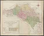
Lubomeriae et Galliciae Regni Tabula Geographica (1775) F.L. Gussefeld
Source: http://www.rcin.org.pl/igipz/dlibra/docmetadata?id=20339 |
 |
|
Carte nouvelle des Royaumes de Galizie et Lodomerie avec Bukowine (1780) T.C. Lotter
Source: http://www.bibliotekacyfrowa.pl/dlibra/docmetadata?id=41380 |
 |
|
General Charte des Atlasses von Galizien und Lodomerien (1790) F.I. Marie
The Zamosc region, at the uppermost center of the map is included in this early configuration of Galicia as is Bukowina which was added to Austria in 1775.
|
_F.I.jpg) |
|
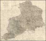
Carte von West Galizien (1808) A.M. von Heldensfeld
|
 |
|
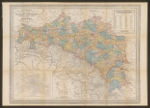
Allgemeine Charte des Koenigreiche Beider Galizien (1804) J. Liechtenstern West Galicia is added to East Galicia here after the third partition. Districts are delineated and named in German and French. Here is an interactive map of the changing borders of Galicia. Use the Toggle layers menu to cycle through the changes. An alternate view of the delineations of West Galicia from the Bibliotheque national de France.
Source: The National Library of Israel |
 |
|
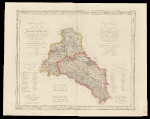
Koenigreich-Galizien (1832) C.F. Weiland The 19 districts of Galicia including Bukowina are delineated here.
|
_C.F.jpg) |
|
General Post-und Strassenkarte des Kronlandes Galizien und Lodomerien mit Auschwitz, Zator und Krakau; so wie des Kronlandes Bukowina (1888) R.A. Schulz
An 1878 version from the Polish National Library website with fewer districts. This 1895 version from From the American Geographical Society Library, University of Wisconsin-Milwaukee Libraries, contains a table of population data.
Source: Bibliotheque nationale de France |
 |
|
Mapa komunika cyjna Galicyi i Bukowiny (1898) S. Kornman
Jagiellonian University Library
|
.jpg) |
|
Galizien und Nordost-Ungarn (1900-1920) C. Flemming
Source: The National Library of Poland |
_C.jpg) |
|
Volkswirthschaftliche Uibersichts-Karte des Herzogthumes Bukowina (1873)
Courtesy of: mapywig.org
|
 |
|
G. Freytags Karte der Bukowina (1915)
|
 |
