Partitions of Poland-Lithuania 1772, 1793 & 1795
The Partitions of Poland [note 1] were three partitions of the Polish–Lithuanian Commonwealth that took place toward the end of the 18th century
and ended the existence of the state, resulting in the elimination of sovereign Poland and Lithuania for 123 years. The partitions were conducted
by Habsburg Austria, the Kingdom of Prussia, and the Russian Empire, which divided up the Commonwealth lands among themselves progressively
in the process of territorial seizures and annexations [1][2][3][4]. In English, the term "Partitions of Poland" is sometimes used geographically as
toponymy, to mean the three parts that the partitioning powers divided the Commonwealth into, namely: the Austrian Partition, the Prussian Partition
and the Russian Partition. In Polish, there are two separate words for the two meanings. The consecutive acts of dividing and annexation of Poland
are referred to as rozbiór (plural: rozbiory), while the term zabór (pl. zabory) means each part of the Commonwealth annexed in 1772–95 becoming
part of Imperial Russia, Prussia, or Austria.
Full article at Wikipedia here.
|
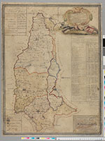
Generalnaia karta oblastei pod Skipetr Vserossiiskii v 1793 godu ot Pol'shii vozvrashchennykh i razdelennykh na gubernii i okrugi s oznacheniem i chastei otdeliaemykh k sopredel'nym namestnichestvam General Map of Regions Restored from Poland and under the Scepter of All-Russian Rule, Divided into Provinces and Districts, with a Description of the Delineated Administrative Parts (1793) Ivan Mironov (Kiev)
An early map of the second Partition, 1793.
Courtesy of Biblioteka Jagiellonska Cracow |
 |
|
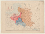
The First Partition of Poland 1772 (1831) A.H. Dufour, L. Chodzko From the Atlas historique, politique et statistique de la Pologne ancienne et moderne indiquant ses divers demembremens et partages: dediee a Joachiom Lelewel. The locations and dates of various battles are indicated with a symbol of crossed swords. A similar map from the Atlas by Jan Bansemer courtesy of the Biblioteka Jagiellonska Cracow.
|
_of_Poland_1831_A.H._Dufour_&_L.jpg) |
|
The Second Partition of Poland 1793 (1831) A.H. Dufour, L. Chodzko From the Atlas historique, politique et statistique de la Pologne ancienne et moderne indiquant ses divers demembremens et partages: dediee a Joachiom Lelewel. A similar map from the Atlas by Jan Bansemer courtesy of the Biblioteka Jagiellonska Cracow.
|
_of_Poland_1831_A.H._Dufour_&_L.jpg) |
|
The Third Partition of Poland 1795 (1831) A.H. Dufour, L. Chodzko From the Atlas historique, politique et statistique de la Pologne ancienne et moderne indiquant ses divers demembremens et partages: dediee a Joachiom Lelewel. The totality of the completed partitions for each offending state is pictured. A similar map from the Atlas by Jan Bansemer courtesy of the Biblioteka Jagiellonska Cracow.
|
_of_Poland_1831_A.H._Dufour_&_L.jpg) |
|
Les Partages de la Pologne de 1770 a 1914 (1914) M. Fallex The borders of the three partitions as well as later boundary shifts resulting in the Duchy of Warsaw, the Tarnopol addition, and Congress Poland are combined in this map.
Source: Bibliotheque nationale de France |
 |
|
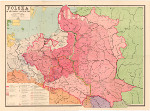
Polska w dobie rozbiorow 1770-1795 (1928) Ksiaznica Atlas The Partitions of Poland during the years 1770-1795
This map delineates the areas partitioned by the surrounding states and the original provincial divisions (woiwodztwa) within the border of the pre-partition Commonwealth of 1772. |
.jpg) |
|
POLSKA w okresie rozbiorow (1958) Zbigniew Rzepa The Partitions of Poland From the University of Wisconsin Milwaukee Digital Ligrary Copyright restrictions may apply
|
 |
