Poland-Lithuania
The Polish–Lithuanian Commonwealth – formally, the Crown of the Kingdom of Poland and the Grand Duchy of Lithuania and, after the Commonwealth of Poland – was a dual state, a bi-confederation of Poland and Lithuania ruled by a common monarch, who was both King of Poland and Grand Duke of Lithuania. It was one of the largest [4][5] and most populous countries of 16th- to 17th-century Europe. At its largest territorial extent, in the early 17th century, the Commonwealth covered almost 400,000 square miles (1,000,000 km2) [6] and sustained a multi-ethnic population of 11 million.[7]
The Commonwealth was established by the Union of Lublin in July 1569, but the Crown of the Kingdom of Poland and the Grand Duchy ofLithuania had been in a de facto personal union since 1386 with the marriage of the Polish queen Hedwig and Lithuania's Grand Duke Jogaila, who was crowned King jure uxoris Władysław II Jagiełło of Poland. The First Partition of Poland in 1772 and the Second Partition of Poland in 1793 greatly reduced the state's size and the Commonwealth collapsed as an independent state following the Third Partition of Poland in 1795.
Full article at Wikipedia can be read here.
All but one of the maps in this section are latter day renditions of the former Polish-Lithuanian commonwealth.
|
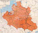
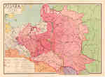
Polska i Litwa za Jagielonow (w.XV) (1929) Ksiaznica Atlas Poland-Lithuania of Jagiello (15th C.)
Source: http://rcin.org.pl/dlibra/docmetadata?id=29336 |
 |
|
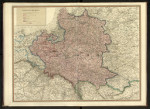
Variations des Frontieres de l'etat Polonais du Xe Siecle a 1770 (1919) M. Fallex
Source: Bibliotheque nationale de France |
 |
|
Poland in the XV-C. (1918) Jan Babirecki
|
-J.Babirecki.jpg) |
|
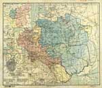
Krolestwo Polskie I Wielkie Ksiestwo Litewskie w latach 1320-1370 (1963) Zbigniew Rzepa
From the University of Wisconsin Milwaukee Digital Ligrary Copyright restrictions may apply Assembled from four images.
|
 |
|
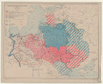
Rzeczpospolita Polska w latach 1505-1648 (1963) Zbigniew Rzepa
From the University of Wisconsin Milwaukee Digital Ligrary Copyright restrictions may apply Assembled from four images.
|
 |
|
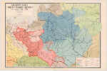
Rzeczpospolita Polska w latach 1648-1764 (1963) Zbigniew Rzepa
From the University of Wisconsin Milwaukee Digital Ligrary Copyright restrictions may apply Assembled from four images.
|
 |
|
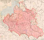
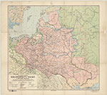
Rzeczpospolita Polska w dobie krolow obieralnych (1933) Ksiaznica Atlas Republic of Poland in the era of royal election
Source: http://igrek.amzp.pl/ |
 |
|
Wielkie Ksiestwa Litewskiego w polowie XVI wieku (1928) Jan Jakubowski The Grand Duchy of Lithuania in the mid-sixteenth century From the: Atlas Historyczny Polski.
Source: http://pbc.biaman.pl/dlibra/docmetadata?id=37239&from=&dirids=1&ver_id=&lp=7&QI= |
 |
|
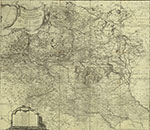
Carte generale et nouvelle de toutte la Pologne du Grand Duche de Lithuanie et des pais limitrofes (1770) Bartolomeo de Folino
Source: http://polona.pl/item/8605960/0/ |
 |
|
Poland in the XVII-C. (1918) J. Babirecki
|
-J.-Babirecki.jpg) |
|
Poland in the year 1771 (1895) J. Babirecki
|
-Jan-Babirecki.jpg) |
|
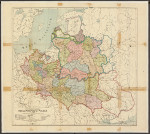
Mappa historyczna Rzeczypospolitej Polskiej w r. 1771 (1925) Ksiaznica Atlas
Source: National Library of Poland |
 |
|
Polska w dobie rozbiorow 1770-1795 (1928) Ksiaznica Atlas The Partitions of Poland 1770-1795
|
.jpg) |
|
POLSKA w okresie rozbiorow (1958) Zbigniew Rzepa The Partitions of Poland From the University of Wisconsin Milwaukee Digital Library Copyright restrictions may apply
Source: http://rcin.org.pl/dlibra/docmetadata?id=29328 |
 |
|
Pologne en Decadence (1850) A.H. Dufour From the: Atlas de l'ancienne Pologne pour servir a l'etude de la geographie naturelle et historique des pays compris entre la Mer Baltique et la Mer Noir.
Source: The National Library of Poland |
 |
